TomTom Mape v8.35
- Ustvarjalec teme MiKi5
- Začetni datum
Uporabljate neposodobljen brskalnik. Ta ali druga spletna stran morda ne bo prikazana pravilno.
Posodobite brskalnik ali uporabite alternativni brskalnik.
Posodobite brskalnik ali uporabite alternativni brskalnik.


8.40 so zadnje mape
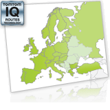
Detailed map seamlessly covering Western and Central Europe - unsimplified version. With IQ Routes™ data for faster routing.
Map coverage statistics:
* countries fully covered (99.9%): Andorra, Austria, Belgium, Czech Republic, Denmark, Finland, France, Estonia, Germany, Great Britain, Italy, Liechtenstein, Lithuania, Luxembourg, Hungary, Malta, Monaco, Norway, Poland, Portugal, San Marino, Slovakia, Slovenia, Spain, Sweden, Switzerland, the Republic of Ireland, the Netherlands, the Canary Islands and the Vatican City.
* countries partially covered: Russia up to the Ural mountains (33%), Bulgaria (54%), Latvia (63%) and Croatia (42%, including major cities and coastal areas)
* roads covered (kms): over 9.7 million
* connector roads: other Central European Countries are covered by a connector network of major roads that allows you seamless navigation throughout the entire region.
sam Grčije ni

Drugač imaš pa:
- Greece_840_2549 (29.31 MB)
- Greece_840_2561 (24.51 MB)
čeprv po mojin informacijah mapa Western_and_Central_Europe_2GB_840 ima tudi Grčijo.
Te mape pa imajo Grčijo sigurno:
Europe_840_2562 (2.08 GB)
Europe_2GB_840_2563 (1.53 GB)
Europe_840_2566 (1.84 GB)
Europe_2GB_840_2566 (1.7 GB)
Europe_2GB_840_2568 (1.72 GB)
Europe v8.40
Download 2013.6 MB
Detailed map seamlessly covering Europe with IQ Routes™ data for faster routing - unsimplified version.
Map coverage statistics:
* countries fully covered (99.9%): Andorra, Austria, Belgium, Czech Republic, Denmark, Estonia, Finland, France, Germany, Great Britain, Italy, Liechtenstein, Lithuania, Luxembourg, Hungary, Malta, Monaco, Norway, Poland, Portugal, San Marino, Slovakia, Slovenia Spain, Sweden, Switzerland, the Republic of Ireland, the Netherlands, the Canary Islands and the Vatican City.
* countries partially covered: Greece (84%) , Turkey (63%), Russia (33%), Bulgaria (54%), Latvia (63%) and Croatia (42%, including major cities and coastal areas)
* connector roads: other Central European Countries are covered allowing you seamless navigation throughout the entire region.
Nazadnje urejeno:

Podobne teme
- Odgovori
- 21
- Ogledi
- 5.492
- Odgovori
- 7
- Ogledi
- 14.887