Prvi Garmin zemljevid celotne Afrike v enem kosu (razen Severnega Sudana)
Podroben očitno ni, ker je samo 370 MB. Ampak končno so združili posamezne variante.
Izšel bo oktobra.
več: https://buy.garmin.com/shop/shop.do?cID=253&pID=117106&ra=true
edit: popravljeno in dopolnjeno
Citat:
Includes more than 4.8 million km (3 million mi) of roads, including motorways, national and regional thoroughfares and local roads.
Covers more than 1.9 million km (1.1 million mi) of non-routable paths and tracks for the ultimate off-road experience.
Displays more than 610,000 points of interest throughout the country, including restaurants, lodging, petrol/gasoline stations, attractions, railways and more.
Gives turn-by-turn directions on your compatible device on the routable road network.
Speaks street names (example: "Turn right on Main Street")
Includes navigational features, such as turn restrictions, roundabout guidance, speed categories and more on the routable road network.
Contains traffic data for compatible devices that use traffic receivers on the routable road network.
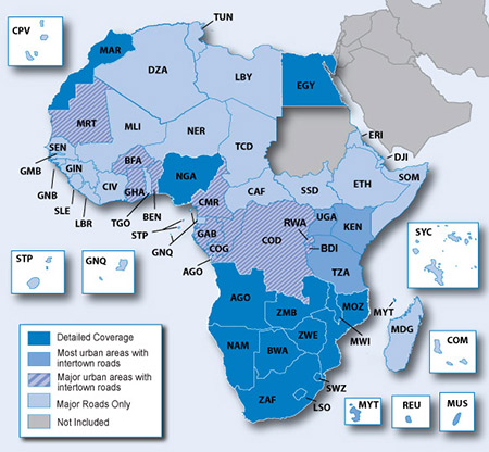
Citat:
Detailed Coverage
Angola
Botswana
Egypt
Lesotho
Malawi
Morocco
Mozambique
Namibia
Nigeria
South Africa
Swaziland
Zambia
Zimbabwe
Urban Area Coverage
Benin
Burkina Faso
Burundi
Cameroon
Congo
Democratic Republic of the Congo
Gabon
Ghana
Kenya
Mauritania
Mauritius
Mayotte
Reunion
Rwanda
Tanzania
Major Road Coverage
Algeria
Cape Verde
Central African Republic
Chad
Comoros
Cote d’Ivoire
Djibouti
Equatorial guinea
Eritrea
Ethiopia
Gambia
Guinea
Guinea Bissau
Liberia
Libya
Madagascar
Mali
Niger
Sao Tome and Principe
Senegal
Seychelles
Sierra Leone
Somalia
South Sudan¹
Togo
Tunisia
¹No map coverage for North Sudan is provided.
Podroben očitno ni, ker je samo 370 MB. Ampak končno so združili posamezne variante.
Izšel bo oktobra.
več: https://buy.garmin.com/shop/shop.do?cID=253&pID=117106&ra=true
edit: popravljeno in dopolnjeno
Nazadnje urejeno:
